Here was our water.
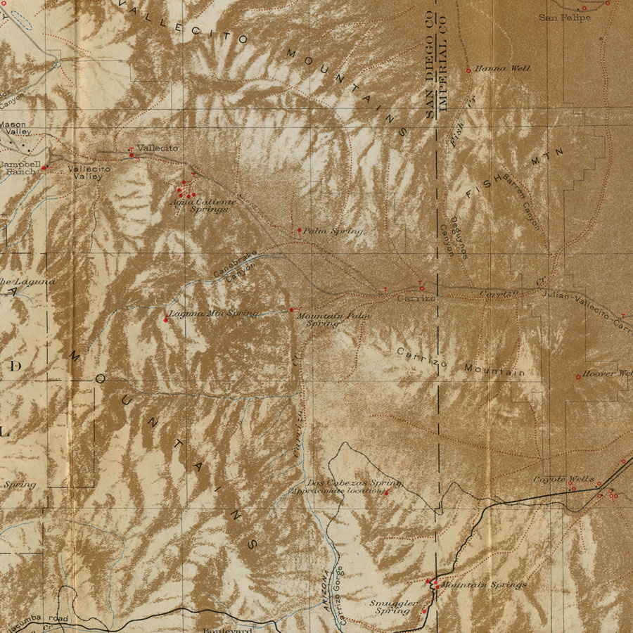
detail, Plate VI. Relief map showing desert watering places in the western half of the Salton Sea region, Calif.
in John S. Brown, Routes to Desert Watering Places in The Salton Sea Region, California. USGS Water-Supply Paper 490–A (1920)
at archive.org — both plates at end, open!
See also David G. Thompson, Routes to Desert Watering Places in the Mohave Desert Region, California. USGS Water-Supply Paper 490-B (1921)
* (google, Stanford copy,
bound together with Brown and 490-C and 490-D, same series, Lower Gila Region and Papago Country, Arizona, respectively.)
folded plates not opened in this scan.
—
“Between Fish Creek Mountain and Coyote Mountain is the cañon of Carrizo Creek, which we had left when we turned north at Agua Caliente. It is a wild, disorderly-looking piece of country. Hills and ridges of strangest shape and color seem to jostle for place. A low cone to our right appeared to be covered with black clay shards like those near Superstition Mountain. Another hill of vivid yellow was capped with the same material. Others were of entire red or purple... The crudity of the landscape here surpassed anything I had yet seen in this region of hard color effects... Your primal home. Come back.” (pages 274, 276)
Bad day, of heat, unpromising terrain, no water —
“My poor Kaweah, I wager you remember that day.” (p 278; Kaweah is the author’s beloved horse.)
“Following the narrowing cañon for a mile or more, we came into a little amphitheatre. Here was our water.” (p 279)
passages ex J. Smeaton Chase (1864-1923 *), California Desert Trails (1919)
* (google, Stanford copy)
* (GDZ Göttingen)
tags: Carrizo Creek; Kaweah
J. Smeaton Chase, California Desert Trails (1919); John S. Brown, Routes to Desert Watering Places (1920)